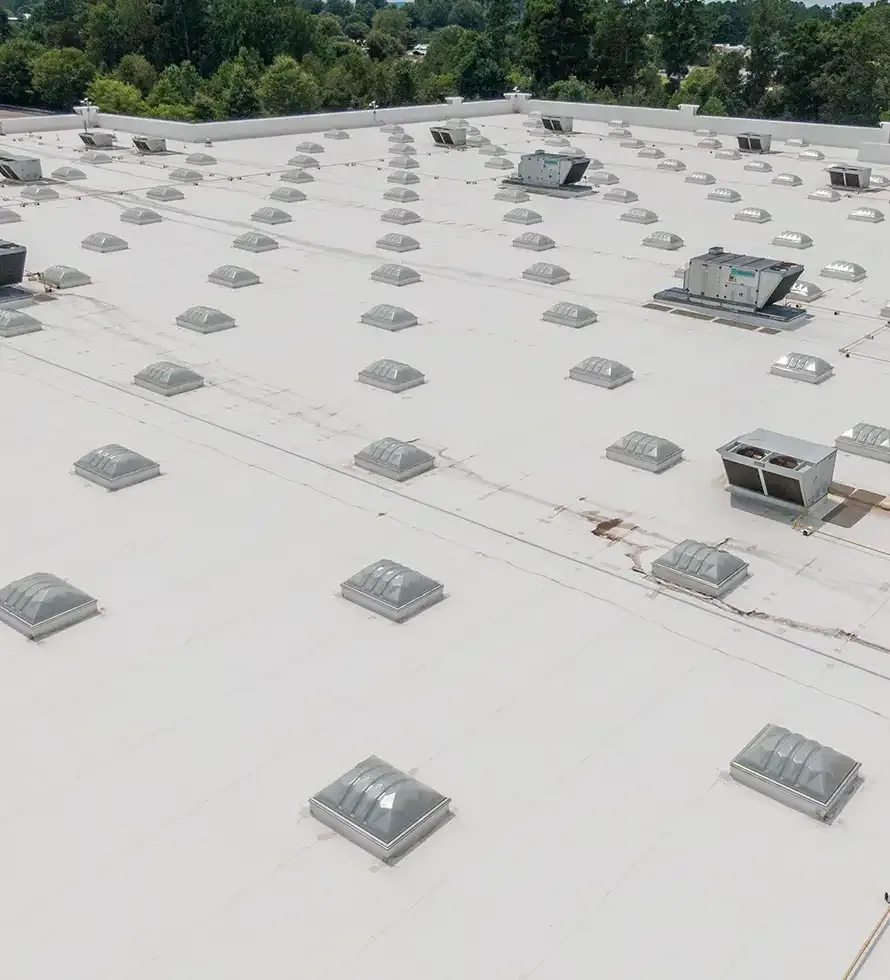
Aerial images can show a roof pattern that is hard to see from a hatch, but they do not identify every defect. In Henderson, NV, a drone roof inspection can help document broad membrane areas, rooftop equipment, and drainage paths while reducing unnecessary foot traffic. We plan the flight around site conditions and the question the owner needs answered, then pair images with a hands-on review of details that require close inspection. The deliverable connects imagery to roof zones instead of leaving the property manager with unlabeled pictures.
Before flight, we confirm permissions, access, safe launch and landing areas, and any restrictions around people or operations. We review available roof plans and note the areas of concern. After capture, we compare the images with field observations and identify where a close-up inspection or test is needed. The method complements a roof walk; it does not replace one.
Plan the Flight Around the Roof
Flight planning starts with the property boundary, roof layout, wind conditions, obstructions, and the purpose of the inspection. We select views that can help locate visible surface changes, blocked drainage, loose materials, or equipment conflicts. Image scale and lighting matter. A wide pass helps orient the report, while detail images may be needed around parapets, curbs, expansion joints, and skylights. If shadows or glare obscure a condition, we note the limit and plan another observation.
Henderson's emergency guidance lists strong winds, thunderstorms, lightning, and extreme heat among local hazards. These conditions can affect flight safety and image quality. We defer aerial capture when weather, airspace restrictions, or site activity makes it unsuitable. Henderson's employment areas include warehouse, light-industrial, office, and manufacturing uses, where loading traffic, rooftop exhaust, or security restrictions can shape a safe flight window. We confirm those details with the property contact rather than assume a clear roof perimeter.
For a full condition picture, we combine aerial capture with a commercial roof inspection. A person on the roof can check membrane flexibility, attachment, seams, and flashing details that an image cannot test. The report identifies which observations came from the flight and which were confirmed at close range.
Read Images With the Assembly in Mind
Aerial imagery is strongest when the roof plan and installed system are known. We use roof-zone labels to relate a view to the structure and note visible drains, curbs, joints, and changes in material. An image may show a discolored area or standing water, but it cannot determine whether the insulation is wet or whether a membrane has lost adhesion. We treat those patterns as questions for a closer look, not as a diagnosis.
Henderson flood-control guidance warns that monsoon storms can deliver intense localized rain and overwhelm drainage. Drone views can help show the general flow path, outlet locations, and broad areas where water remains after a storm. A close inspection is still needed to check slope, drain connections, and the condition around a scupper or bowl. Our drainage review checks those details at roof level and distinguishes a temporary obstruction from a condition that needs repair.
Images may help track rooftop equipment and access routes over time. When units, supports, or ducts change, flashing and curb details can be affected. A curb inspection verifies the transition and identifies work that should be coordinated with mechanical service. We also compare capture dates and weather context so a later report does not confuse a new condition with an old image.
Turn Capture Into a Work Plan
The deliverable includes an overview, labeled roof-zone views, notable observations, limitations, and recommended follow-up. We connect each observation to a specific question: Is the membrane visibly displaced? Does the area need close inspection? Is the drain obstructed? Does a potential moisture pattern warrant direct testing? Those questions guide the next site visit and prevent visual detail from being mistaken for verified condition. We label each view with its direction and roof zone, preserve the capture date, and note any obstruction that limits coverage. That gives the next inspector a way to return to the same area and compare change using documented views instead of memory.
When concealed moisture is the concern, infrared scanning can be a separate diagnostic step under suitable conditions. A drone camera and thermal equipment do not provide the same evidence. Thermal differences need interpretation and, where material decisions depend on them, confirmation by test cut or another direct method. The report makes that distinction clear so a budget decision is based on the right evidence.
If the images show a repair candidate, we inspect the detail and define a compatible scope. That may involve a seam, edge, penetration, or localized surface damage. A documented condition report can place the image set alongside inspection notes and repair options. The property manager can then compare immediate action with planned maintenance or a larger roof project.
Respect Building Activity
Drone work needs coordination with the people using the property. We agree on the flight window, temporary keep-clear areas, access for a ground observer, and any restrictions around sensitive equipment or neighboring operations. If a tenant is receiving a delivery or working under the flight path, we reschedule or change the capture plan. The site contact knows who is operating, where the aircraft will launch, and how the crew will communicate during the inspection.
The West Henderson Global Business District is an employment and innovation area in the city's plans, while Water Street supports a mixed-use downtown setting. These broad areas illustrate why a flight plan is property-specific: access, activity, and surrounding uses can differ even within one market. We do not publish a specific building's imagery or infer roof conditions from the district. The owner receives the images and observations for the property being inspected.
For repeat inspections, we can use a consistent set of roof zones and viewpoints when conditions permit. Comparison is more useful when capture dates, weather, camera angle, and changes to equipment are recorded. A West Henderson service visit or Water Street District inspection still begins with those property-level controls, not an assumption that every roof can be flown the same way.
Plan an aerial roof assessment
Send the roof plan, areas of concern, site access requirements, and operating hours. We will confirm flight conditions and pair image capture with the inspection the roof needs.
Related Roofing Work
More roofing work and building types connected to this page.